The Other Side of the Hill
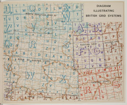
This diagram was issued by the Directorate of Military Survey in March 1944 to highlight areas where overlapping grid systems might be found on one map. S696.a.94.48. Crown Copyright.
The Duke of Wellington said that ‘All the business of war… is to endeavour to find out what you don’t know by what you do; that’s what I called “guessing what was at the other side of the hill”.’ For tactical military purposes, the most important intelligence is often relatively straightforward data regarding the strength and movements of the enemy’s forces or the location and physical characteristics of possible areas for attack. Napoleon used an observation balloon during the Nile campaign at the end of the eighteenth century, and since then much guesswork has been obviated by information-gathering at altitude—whether by spotters above the Western Front in the First World War or by satellites in our own day. Sources such as commercially-produced cartographic materials and topographical photographs have also been employed with regard to static targets like coastlines or cities. The annotated map, if timely and accurate, has proved to be one of the most powerful of all genres of intelligence.
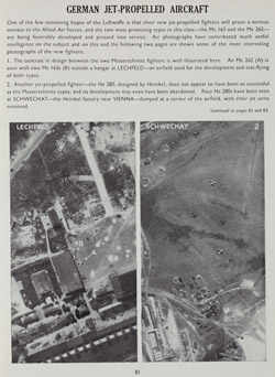
A page from a September 1944 issue of the restricted Air Ministry periodical Evidence in Camera, demonstrating the intelligence value of aerial reconnaissance photography. OP.2100.30.018(8). Crown Copyright.