Contents
The indices were developed over a long period of time alongside the transcription of the records. The links we have made, particularly for individuals and land, are based on indexes that we developed before computers could help us with powerful search engines. As such they are open to some reinterpretation.
This index makes all records available in chronological order of the date of the making of a document. The intensive data span is from 1375 to 1750, but there are records both before and after these dates that have been included.
Jump to...
| Unknown | 1100-1199 | 1200-1299 | 1300-1399 | 1400-1499 | 1500-1599 | 1600-1699 | 1700-1799 | 1800-1899 | 1900s |
This index does not contain every named person but attempts to identify particular individuals referred to in the documents. As the records only survive in sufficient variety to make a clear identification possible from the middle of the sixteenth century it does not include people only referred to before 1559.
Each person has been given an unique identifier consisting of the first letter of the surname and a number. Thus the three separate Abigail Abbots are A1, A2, A3.
Aliases are listed under all names. For women, the earliest surname generally provides the identifier; all other references with later surnames through marriage or subsequent marriages have been grouped with the first identifier. Thus A66 is Sarah Abbot, who became Sarah Hayward by her first marriage and Sarah Gover by her second marriage. All references to her are together under A66 in the Aindex, but there are cross-links to her in the G and H indices.
References that are too ambiguous to make a firm identification possible appear in brackets with a question mark. The ambiguous references are also listed separately under identifiers with an 'x' suffix.
A personal name is the necessary link in all records except for Josselin's diary. There we have made specific links to "wife" etc. as the diarist rarely mentions her by name, and to other unnamed members of the family where we can infer by the context about whom he is writing.
Jump to....
For all names where there is no specific identifier the various spellings of the same forename/surname have been linked to key names and they are shown in a chronological list. It is unnecessary for the user to know a key name or its synonyms when searching but they are an extension of the list used for indexing individuals. Some synonyms may look unlikely but they reflect variants found in the data.
The synonyms can be seen in the indices of forenames and surnames.
Jump to....
Manorial land that can be located on the map or street plan has been indexed by name and plot number. Variant spellings are listed on selection of a key name. Some fields and houses can be easily identified but others share names or change names. Individual parcels can be traced by looking at specific plot numbers.
Jump to....
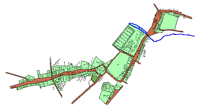
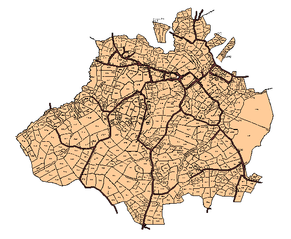
The map of the manorial lands of Earls Colne and Colne Priory has been drawn to reflect changes in the shape and size of fields between 1598 and 1854. It is based on a manorial map and terrier, which also included sketch maps of individual holdings, drawn by Israel Amyce in 1598, and a map illustrating the tithe award of 1838. Confirmation on many of the alterations in field shapes between these dates comes from a detailed survey of manorial lands made by H.H. Carwardine, lord of both manors, in 1854.
The tithe award field numbers have been used as a basis for indentifying land with letters added, where relevant, to reflect changes in shape over time. For instance, plot 178 on the tithe map appears as 178, 178a & 178b on our map, reflecting the changes since 1598 when there were three fields in this same area. Click on the map to zoom in on a specific area.
The street plan is based on one within the terrier accompanying the 1598 map and the conventions follow the same form as the map above with numbering taken from the tithe award. Click on the map to zoom in.