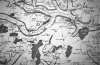
Earls Colne is named after the river Colne upon which it lies and the Earls of Oxford who owned the manor from before the start of our documents and who were often buried there. It is five miles from the market town of Coggeshall, ten miles from Colchester and about forty miles north east of the city of London (see map). With a total circumference of approximately ten miles and an area of just under three thousand acres, it constituted a tiny part of the land area of England. Likewise its total population, which fluctuated between 500 and 1000 persons during this period, only constituted roughly one hundredth of the population of the county of Essex and one ten thousandth of the total population of England and Wales. Despite this, and despite the regional diversity of England, there are grounds for believing that we are observing in this parish a microcosm of life not only in north-eastern Essex or East Anglia, but in England in general. How far Earls Colne was exceptional within Essex and Essex within England will be discussed at various points. But a few of the outstanding and fairly constant features of the parish over the whole three hundred and fifty years may be briefly described.
Earls Colne lies in the boulder clay plateau of northern central Essex at a height of between 100 feet and 400 feet above sea level, in an area of small hills and valleys. Although there were traces of open field cultivation in the fifteenth century, most of the parish, like much of central Essex, had been early enclosed into small fields with hedges. Most of the old forest had receded, except for one large medieval woodland called Chalkney Wood comprising about a fifteenth of the parish. There were also a few alder groves and marshes, but most of the rest of the land was used for mixed farming. The use of the land changed very greatly during the period 1400-1750. In the seventeenth century, for example, the crops included grain, hops, fruit, and vegetables and there were various kinds of animal husbandry. Although the river Colne which formed the northern border was not navigable at this point, its waters drove two mills. The main communications were along roads to Coggeshall, Colchester and Halstead, including the main Cambridge to Colchester road which ran through the village. Much of the produce from the village was taken in this way down to Colchester where it was carried by water to other ports, including London. Apart from agriculture, the main occupations were shop-keeping and petty manufactures. There was a fair on Lady Day (March 25th) and numerous shops and inns. There was a market place with open stalls in the middle of the village. Occupations altered very considerably through the centuries. As well as smiths, tanners, millers and other occupations there were, particularly from the later sixteenth century with the influx of Dutch immigrants into north eastern Essex, considerable numbers employed in spinning and weaving cloth for export all over Europe. In all these respects, Earls Colne was similar though not identical to other villages in northern and central Essex.
The size of the village fluctuated very considerably over these three hundred and fifty years, from a lower limit of a little over a hundred dwellings to an upper limit of twice that number. In 1598, when there is a map, there were 139 houses (140 including Colne Priory). Many of these were subdivided. Two thirds of the houses lay in the main village along the street, the other third was scattered as farms and cottages through the rest of the parish: a nucleated settlement pattern characteristic of this part of Essex. There were also several larger buildings: the parish church of St. Andrew; the buildings of the small Benedictine Priory of Colne which flourished until 1534; the central residence of the lords of the manor which was several times rebuilt, being moved from near to the church to the site of the dissolved Priory.
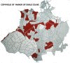
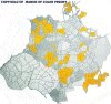
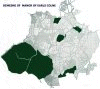
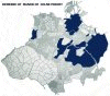
When we turn to the landholding pattern, we find that less than two hundred acres of Earls Colne was held by 'free deed' or freehold directly of the King. The rest was held in two lordships: the manor of Earls Colne and Colne Priory. During the period from 1137 up to 1583 the former was held by the Earls of Oxford as part of the Earldom. The seventeenth Earl sold it in that year to Roger Harlakenden whose descendants have held it ever since. The other, the manor of Colne Priory, was held by the Priory until 1534 and then granted a few years later to the Earls of Oxford until they sold it to the same Harlakenden family in 1592. Approximately two fifths of each of the two manors were let out to tenants by copyhold tenure, the other three fifths were held directly by the lords as demesne. During the course of time, some of this land was formed into largish farms usually of between fifty and one hundred acres such as Hay House and Curds.
| Types of holding in Earls Colne and Colne Priory manors | ||
|---|---|---|
| 
| 
|
| Earls Colne copyhold | Colne Priory copyhold | Earls Colne demesne |
| 
| 
|
| Colne Priory demesne | Earls Colne freehold | Colne Priory freehold |
It is clear from the many surviving records that there was very considerable social mobility in the parish, both vertical and geographical. Many people spent only a few weeks or years there and the boundaries of the parish were not strong barriers. Many owned property both within and outside the parish. Kinship, commercial and other ties cut across the parish boundary. We have thus chosen a somewhat artificial entity, recognized as the basic unit of ecclesiastical and civil jurisdiction and, by chance, coinciding more or less with manorial boundaries, yet not constituting a closed and discrete 'community'. It is a geographical and administrative space through which we can watch a tiny part of the population of England move over the centuries. This particular space was not chosen because it seemed in any way exceptional in its social or economic situation, but because certain types of record in which we are interested survived unusually well.
To learn more about Earls Colne as it is today, visit the Discovering Earls Colne web site.
We have endeavoured to make this site accessible to as many users and web browsers as possible. Readability and short download time have been our goal over stunning visual effects. Use of colour is supplementary: those users without access to colour browsers should not be disadvantaged. All style is implemented using CSS stylesheets level 1. Should your browser not support CSS, pages should still be readable. If you have difficulty with the colours or formatiing provided by our stylesheets, you may find that your browser is capable of using a different stylesheet, or ignoring stylesheet information altogther. HTML Tables are used to create the effect of a document margin. This site makes no use of HTML Frames, Java, JavaScript, ECMAScript, VBScript or Dynamic HTML.
We should like to thank the archivist of the Essex Record Office and the staff, and the staff of the Public Record Office, who played such a large part in making this venture possible. The Social Science Research Council and the Research Centre of King's College, Cambridge originally funded the project. Throughout the project, Cambridge University, particularly the Computing Service and Department of Social Anthropology, have provided excellent facilities. Further support has come from the Renaissance Trust.
The members of the original reseach team were: Sarah Harrison, Charles Jardine, Tim King, Jessica King and Alan Macfarlane with an invaluable contribution from Cherry Bryant. Ken Moody has given support and advise through both phases of the project.
This web site has been created by Tim Mills and Sarah Harrison, with the assistance of Paul Caldwell, Technical Officer at the Department of Anthropology.