Aiding the TravellerFor many of us it is natural to look at a map when planning an unfamiliar journey. However, it was not until the second half of the seventeenth century - prompted by the publication of John Ogilby’s road atlas in 1675 - that maps began to include roads. In earlier times a map might have been used to make a rough plan of a journey in advance, and from 1625 tools such as the triangular distance table were also available, but travellers on the road beyond their home territory would have hired local guides, asked for directions, or followed written itineraries listing the places through which they needed to pass. In contrast the modern traveller sometimes feels overwhelmed by the multitude of maps, guide books and satellite navigation systems available now that people have become more mobile and more adventurous, and as technological developments have galloped ahead. To view images of George Taylor's road book of Scotland, click here. 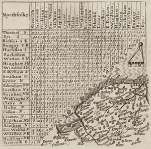
A triangular distance table supplying the distances between towns in Norfolk, from Matthew Simons, A direction for the English traviller…, London, 1643. Atlas.7.64.5 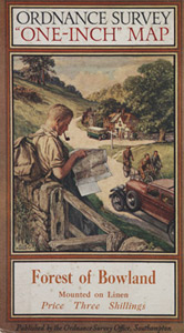
Designed by Ellis Martin, this map cover was used on many Ordnance Survey one-inch maps in the 1930s |