Jn Moy 3.11.1852 surrender of Wm Batt and others
copyhold of Priory - quitrent 13s8d
to all those lands formerly called Booms otherwise Boomfields with the messuage, barn and building therein erected, and containing by estimation with other lands held therewith of the manor of Earls Colne called Gosses , 19a
copyhold of Earldom - quitrent 3s8d
to lands, tenements etc called Gosses or otherwise containing by estimation with other lands held herewith of the manor of Colne Priory called Booms otherwise Boomfields , 19a
1763 Francis Ruffle will of grandfather Jn Newton
1819 Benj Ruffle surrender of Francis ( Gosses called 5a )
23.5.1826 Benj Ruffle to parcel of the waste of manor of Colne Priory lying at the south-west end of barn, copyhold of said manor containing in length 100ft and in breadth 52ft - quitrent 1s
1836 Thos Batt surrender Benj Ruffle
1850 Wm Batt and others death and will of Thos Batt
1852 purchase fine - both manors £63
Commutation map 1836
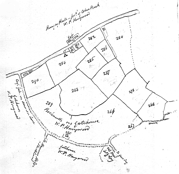
283 (283) homestead and orchard 2r9p Booms Tenement and parcel from the waste copyhold of Priory
284 (284) Barn Field 5a20p - parcel Booms copyhold of Priory and parcel Gosses at the Reeve copyhold of Earldom
288 (288) (288a) (288b) Jones Field 8a3r29p Booms copyhold of Priory
290 (290) Small Booms 3a1r28p Gosses at the Reve copyhold of Earldom
18a6p
There is a blunder in the Commutation map in assigning the field no. 288 (288) 8a3r29p to W.P. Honywood as parcel of The Gatehouse Farm - and no. 289 (289) 8a1r22p (which is parcel of The Gatehouse ) to Booms - This transposition is easily corrected between the respective proprietors - but is of more consequence in the tithe apportionment - it adds 2r7p to Booms and The Gatehouse is minus the same quantity - It has been corrected in the Parish Rate Book, and noted on the map
survey 1598 - fo. 107 - 108 and 109 - Booms was a large property containing altogether now in the respective tenures of Jn Moy Jonathan Hutley and Rich H. Solley - The quantity of Moy's portion appears to be about 13a# in both manors - The property being long in the possession of the same hands has been so divided and subdivided so that it is difficult to identify the present form with the old survey

copyhold lands belonging to Jonathan Hutley late Jas Cowlin and copyhold lands belonging to Jn Moy late Wm Batt from the Commutation map 1836
Booms and Gosses at the Reve continued - survey 1598 Rich Parker Gosses at the Reve 6a3r26p - copyhold of Priory. This leaves about 11a for Booms which corresponds with the quantity of the Commutation map
abstract of title to Booms copyhold of Priory - no. 59, ditto to Gosses copyhold of Earldom note 19
reference to the opposite map (to sketch plan)
no. 345 (345) homestead and garden etc. 1r33p free deed of Priory
(following copyhold of Priory) 268 Gravel Pit Field 3a1r17p
278 (278) Stone Field 5a36p
285 (285) Three Acres 3a2r8p
286 (286) The Pasture 1a38p
287 The Case Field 4a
total 17a1r19p
282 (282) Home Field freehold
held by Jonathan Hutley - late Jas Cowlin see p. 102
no. 283 (283) homestead and orchard 2r9p copyhold of Priory
enclosure from the waste
284 Barn Field 5a20p part copyhold of Priory and part of Earldom
288 (288) (288a) (288b) Jones Field 8a3r29p copyhold of Priory
290 (290) Small Booms 3a1r28p copyhold of Earldom
total 18a6p
held by Jn Moy late Wm Batt - see page 128
In Commutation map no. 288 (288) containing 8a3r29p is entered as mr Honywood's land parcel of The Gatehouse Farm and no. 289 (289) adjoining 8a1r22p parcel of the Gatehouse is entered as belonging to Wm Batt now Jn Moy - the error has been corrected in the parish map H.H.C 1854
no. 291 (291) Dan Cowlin's cottage etc. - see page 48