|
 |
Surprising as it may seem to us today, roads were not usually included
on early maps. It was not until the second half of the seventeenth
century that maps become commonly used as travel aids. Previously,
‘travailers’ venturing beyond their home territory would
have hired local guides, asked for directions or followed written
itineraries which listed the places through which they needed to
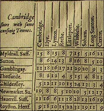
pass. In 1625 John Norden published a set of triangular distance
tables, invented as a guide for travellers. Fifty years later, in
1675, came another innovation - the publication of John Ogilby's
Britannia, containing strip-maps of the post roads of England and
Wales.
|